Tibet’s Cultural Regions: Exploring TAR, Kham, Amdo and the Ancient Silk Road
Tibet, often called the “Roof of the World,” is a land of breathtaking landscapes and deep spiritual significance. While many travellers are familiar with the Tibet Autonomous Region (TAR) with its iconic Potala Palace and Mount Everest, the broader Tibetan cultural sphere encompasses two other historically significant regions: Kham in the southeast and Amdo in the northeast. These areas, combined with the ancient trade routes of the Silk Road, offer an unparalleled journey into the heart of Tibetan civilisation.
Overview: The Three Tibetan Regions
| Tibetan Region | Core Saying | Travel Theme |
| Ü-Tsang | The best religion comes from Ü-Tsang” / “Dharma Ü-Tsang” | Cultural & Religious Heartland |
| Kham | “The best men from Kham” / “Human of Khampa” | Rugged Landscapes & Vibrant Cultures |
| Amdo | “The best horses from Amdo” / “Horse-land Amdo” | Vast Grasslands & Monasteries |
1. Ü-TSANG (Central Tibet) — The Religious Heartland
Ü-Tsang is considered the centre of Tibetan civilisation, from historical, cultural, political, and economic perspectives. It is the birthplace of Tibetan Buddhism’s most powerful lineages and home to the most sacred religious sites.
Geographic Scope
Ü-Tsang covers the south-central Tibetan Plateau, centred on the Yarlung Tsangpo River valley system. It comprises two main areas:
- Ü: The eastern portion, including the Lhasa River valley system (Lhasa), the Yarlung and Chonggye valleys
- Tsang: The western portion, extending from Gyantse westward, including Shigatse
- Ngari (Ali): The far western districts, including Mount Kailash, historically incorporated into Ü-Tsang
Modern Administrative Equivalents
Tibet Autonomous Region: Lhasa City, Shigatse City, Shannan (Lhoka) Prefecture, Ngari Prefecture, most of Nyingchi (western part), parts of Nagqu
Key Destinations
| Destination | Highlights | Travel Notes |
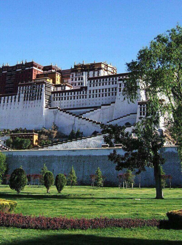
| Lhasa | Potala Palace, Jokhang Temple, Barkhor Street, Sera Monastery | Cultural capital; best for altitude acclimatisation |
| Shigatse | Tashilhunpo Monastery, Gyantse Kumbum, Sakya Monastery | Gateway to Everest |
| Everest Region | Everest Base Camp, Rongbuk Monastery | Border permit required |
| Ngari (Ali) | Mount Kailash, Lake Manasarovar, Guge Kingdom | Most remote; requires 10+ days; border permit required |
| Lhoka (Shannan) | Yumbulagang Palace, Samye Monastery (first monastery), Tombs of Tibetan Kings | Cradle of Tibetan civilisation |
| Chamdo | Ranwu Lake, Laigu Glacier, Riwoche Monastery, Qamdo Monastery | Accessible via Sichuan; part of the “Southeastern Tibet” circuit |
| Nyingchi (Linzhi) | Namcha Barwa, Yarlung Tsangpo Grand Canyon | “Tibet’s Switzerland”; lower altitude |
Practical Information
- Tibetan dialect: Ü-Tsang dialect (Lhasa dialect serves as lingua franca)
- Primary access: Lhasa Gonggar Airport; Kathmandu-Lhasa international flights; Qinghai-Tibet Railway
- Permit requirements: Tibet Travel Permit required for all foreign nationals; Border Permit required for the Everest region, Ngari, and areas near the Nepal border
2. KHAM (Eastern Tibet) — The Land of Warriors
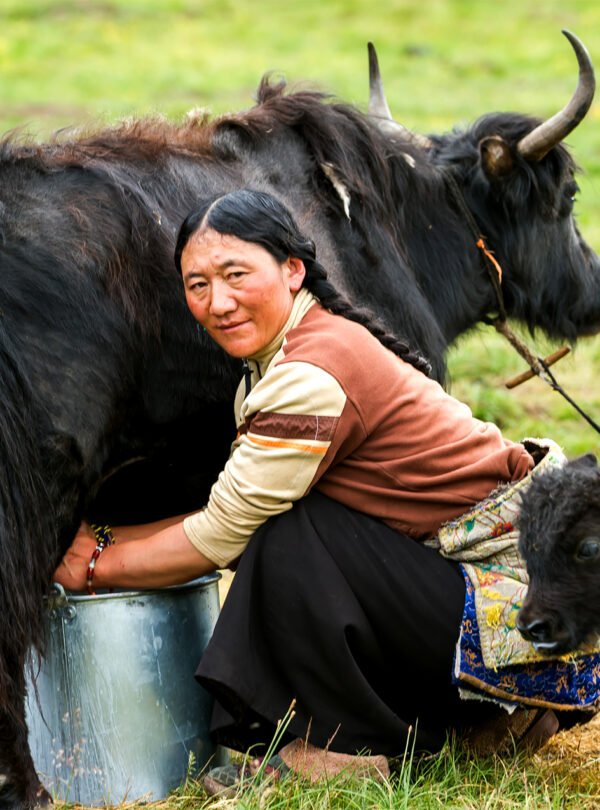
Kham is a vast region stretching across the Hengduan Mountains, known for its rugged terrain, fierce warriors, and independent spirit. The saying goes that Kham produces “the best men” or “Human of Khampa”.
Geographic Scope
Kham traditionally refers to the area east of Ü-Tsang, spanning the Hengduan Mountains in the southeastern part of the Tibetan Plateau. It includes high mountains and deep valleys carved by major rivers (Mekong, Salween, Yangtze).
Modern Administrative Equivalents
- Tibet Autonomous Region: Chamdo City, eastern Nagqu Prefecture, eastern Nyingchi Prefecture
- Qinghai Province: Yushu Tibetan Autonomous Prefecture
- Sichuan Province: Garze Tibetan Autonomous Prefecture
- Yunnan Province: Diqing Tibetan Autonomous Prefecture (Shangri-La)
Key Destinations
| Destination | Highlights | Travel Notes |
| Jyekundo (Yushu) | Remains of the 2010 earthquake; traditional Khampa culture | Remains of 2010 earthquake; traditional Khampa culture |
| Kandze (Garze) | Litang (the highest city in the world), Tagong Grassland, Derge Parkhang Printing Press, Dzogchen Monastery, Daocheng Yading | “Shangri-La” gateway; stunning mountain scenery |
| Diqing (Shangri-La) | Old Town of Shangri-La, Songzanlin Monastery, Tiger Leaping Gorge, Pudacuo National Park, Meili Snow Mountain | Most accessible Kham region; no Tibet Permit required |
Practical Information
- Tibetan dialect: Kham dialect (distinct from Ü-Tsang and Amdo)
- Primary access: Highways from Sichuan (G318, G317) and Yunnan; airports in Chamdo, Daocheng, Shangri-La
- Permit requirements: Varies by province:
- Sichuan/Yunnan/Qinghai portions: No Tibet Travel Permit required (only standard Chinese visa)
- Tibet AR portions (Chamdo, etc.): Tibet Travel Permit required
3. AMDO (Northeastern Tibet) — The Land of Horses
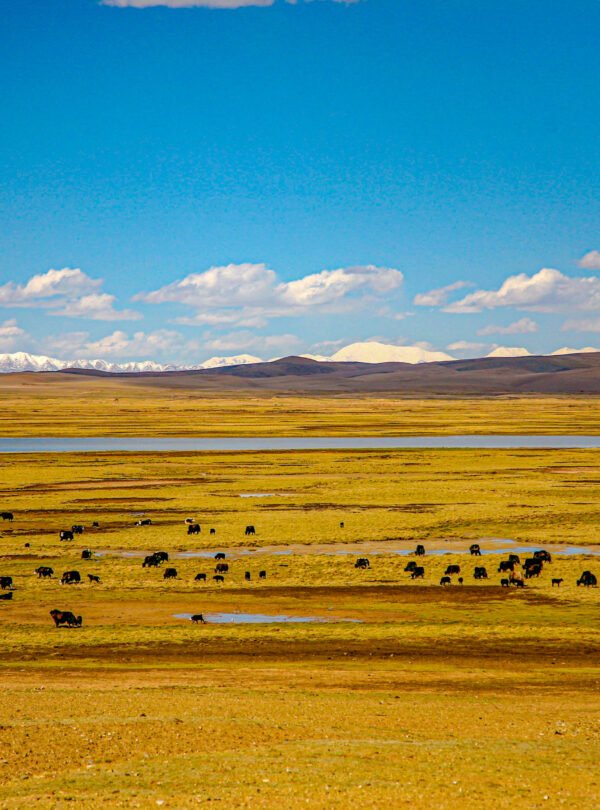
Amdo is the vast northeastern Tibetan region, characterised by expansive grasslands, nomadic culture, and a strong Mongolian influence. It is known as “the land of horses”.
Geographic Scope
Amdo covers the area around Qinghai Lake and the Amnye Machen range, stretching from the Anyemaqen Mountains in the south to the Qilian Mountains in the north. It includes the upper Yellow River watershed.
Modern Administrative Equivalents
- Qinghai Province: Most of Qinghai’s Tibetan autonomous prefectures (excluding Yushu): Hainan, Haibei, Huangnan, Golog, Haixi
- Gansu Province: Gannan Tibetan Autonomous Prefecture
- Sichuan Province: Parts of Aba Tibetan and Qiang Autonomous Prefecture
Key Destinations
| Destination | Highlights | Travel Notes |
| Xining Area | Kumbum Monastery (Ta’er Si) – birthplace of Tsongkhapa, Qinghai Lake (China’s largest inland lake) | Main entry point to Amdo |
| Qinghai Lake | Bird Island, biking circuit, nomadic culture | Sacred lake; Tibetan pilgrimage site |
| Gannan | Labrang Monastery (one of six great monasteries of Gelug), Langmusi, Sangke Grassland, Zhagana Village | Rich monastic culture; accessible via Lanzhou |
| Golog | Qinghai Amnye Machen (sacred mountain), Gyaring Lake, Ngoring Lake | Remote nomad country; adventure travel |
| Ngawa Aba | Dzoge Grassland, Langmusi, Danpa (Watch Tower), Jiuzhaigou | High altitude grasslands; Tibetan-Qiang culture |
| Regong | Two Thangka Painting School, Rongwo Monastery, Tsekor Nomadic area, | The vibrant artistic soul of the Tibetan plateau |
Practical Information
- Tibetan dialect: Amdo dialect (archaic; preserves many Old Tibetan features)
- Primary access: Xining is the main gateway; Lanzhou serves Gannan; Chengdu serves northern Aba
- Permit requirements: No Tibet Travel Permit required (only standard Chinese visa) – Amdo is outside the Tibet Autonomous Region
- Cultural influences: Strong Mongolian and Han Chinese influences are reflected in customs and physical characteristics
4. The Silk Road Connection: The Tea-Horse Road
While the northern Silk Road skirted the edges of the Tibetan Plateau, a southern network of trails known as the Tea-Horse Road (or Chama Gudao) was the lifeblood of trade and cultural exchange for centuries. This ancient route connected tea-producing areas of southern China with the highlands of Tibet, passing directly through the Kham region.
- Historical Significance: Caravans of horses and mules carried tea, salt, and silk from China into Tibet, returning with horses, herbs, and other goods. This trade fostered a unique cultural fusion. Towns like Chamdo in TAR and Dukezong Ancient City in Shangri-La, Yunnan, flourished as key hubs on this route.